
Research Project Full Title: State of Texas Flood Response Study/Annex to State Mitigation Plan
Principal Investigator(s): David R. Maidment
Researchers: David Arctur, Harold Evans, Lukus Godbout
Sponsor(s): Texas Department of Emergency Management
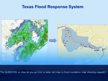
Full Abstract: The National Weather Service (NWS) is developing a National Water Model that will provide significantly higher levels of clarity and detail than ever before with near real-time forecasting of flood water heights for the rivers and streams of Texas. The river and stream network in Texas is comprised of 102,000 uniquely identified “reaches” or segments. Because of this detail, forecasts can now be produced for each individual reach. The purpose of this project is to produce a set of flood response maps for Texas that can be linked to the NWS flood forecast and depict the likely extent of flood inundation on a regional basis anywhere in the state. In addition, a planning template will be prepared for implementation at the local scale of an individual first response unit that shows the NWS levels of minor, moderate and major flooding with the expected flood impact and recommended actions to be taken during a flood event.
Additional Links:
TDEM Presentation by David Maidment
KXAN story on how UT scientists are tackling flood response in Texas